anaglyph
I = anaglyph(G|fname; vscale=1, sscale=2, kw...)I = anaglyph(G|fname; view3d::Bool=false, zsize=4, azim=190, dazim=2, cmap="gray", kw...)Generate an anaglyph image from the input GMTgrid G or grid's file name fname.
An anaglyph 3D is the stereoscopic 3D effect achieved by means of encoding each eye's image using filters of different (usually chromatically opposite) colors, typically red and cyan. Anaglyph 3D images contain two differently filtered colored images, one for each eye. When viewed through the "color-coded" "anaglyph glasses", each of the two images is visible to the eye it is intended for, revealing an integrated stereoscopic image (ref Wiki).
This function offers two methods to create anaglyphs from a gridded terrain model. The first one, based on a simple gradient of the surface elevation, is very fast, takes a little while to fool the brain (that is, to make it think it's looking into a true 3D surface) but gives a very impressive feeling of depth. The second method, that generates 2 3D views using the grdview program and construct the anaglyph from those two images, is slower and creates a less perceptually depth image but it is easier to see and displays more 3D info.
Args
G: The input GMTgrid or filename of data to be processed.
Kwargs
vscale: Terrain vertical scale factor (default: 1). Applies only to first method.sscale: Stereo separation scale factor (default: 2). Applies only to first method.R: Region of interest when reading a grid from disk (default: entire grid). Ignored whenGis a GMTgrid.view3d: If true, selects an alternative and slower method that generates 2 3D views using the grdview program and construct the anaglyph from those two images (default: false).zsize: z-axis size of the 3D view. Same as in grdview (default: 4 cm).azim: Azimuth of the 3D view (default: 190).dazim: Azimuth step (default: 2). It means, create the anaglyph from the pair of images obtained withazimandazim - dazim.cmap: Color map (default: "gray").
Returns
An anaglyph GMTimage suitable for viewing with red-cyan glasses.
Credits
The method that uses the grid's gradient is based on an ancient program called ManipRaster by Tierrt Souriot. The second method, the one that uses the grdview program, was proposed by Tim Hume in the GMT forum. (https://forum.generic-mapping-tools.org/t/bringing-the-third-dimension-to-gmt-stereograms/6189)
Examples
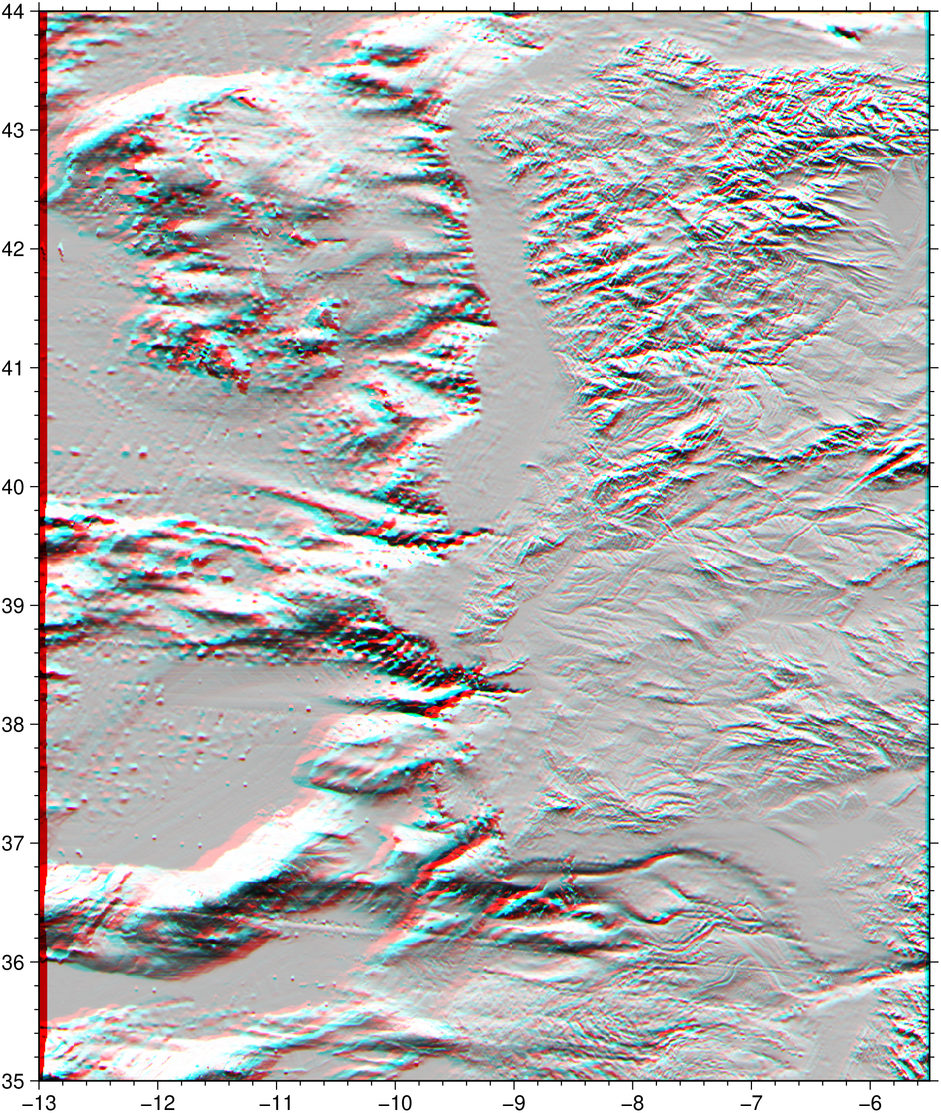
Create an anaglyph of first type overt the Iberian peninsula.
using GMT

I = anaglyph("@earth_relief_30s", region="-13/-5.5/35/44")
viz(I)
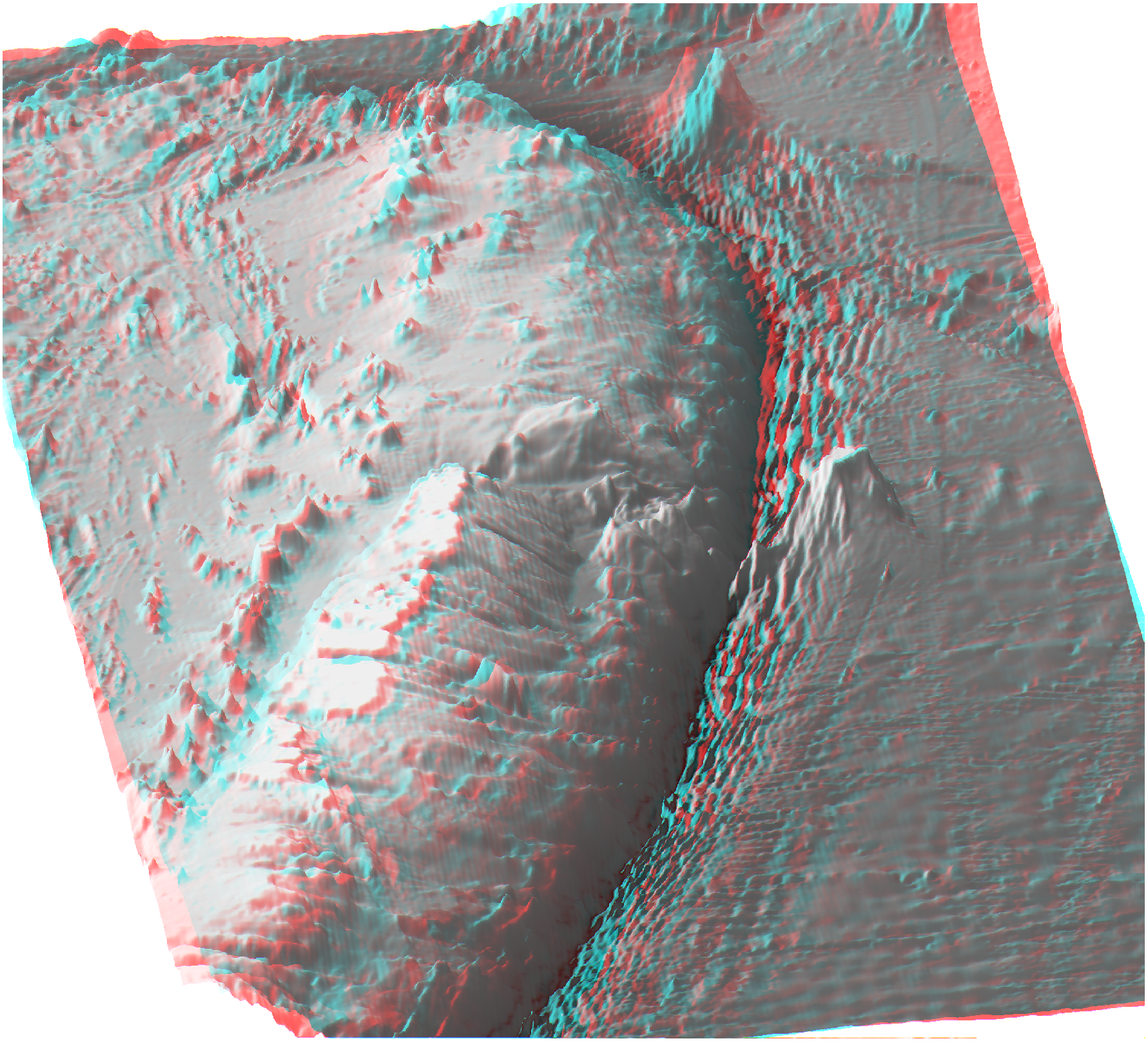
Now let us see the Tonga Trench using the second method.
using GMT

I = anaglyph("@earth_relief_30s", R="-175.8/-171/-23/-14", view3d=true)
viz(I)
These docs were autogenerated using GMT: v1.33.0